
Neighborhood Centers
Project update
The public is invited to attend an online open house to learn about recommendations to support neighborhood centers in Olympia. The event will be held virtually, starting with a presentation from the report’s authors, MAKERS Architecture and Urban Design. Participating community members will have the chance to ask questions of City staff and provide feedback.
When & where?
- Thursday, May 16, 2024
- 5:30 p.m.
- Zoom (register)
What's happening?
Neighborhood centers are small walk, bike, and transit-friendly business clusters within residential neighborhoods that serve the day-to-day retail and service needs of local residents and foster community interaction. Neighborhood centers are important to community-wide goals to increase walkability, reduce our carbon footprint, improve human health, and foster neighborhood resiliency.
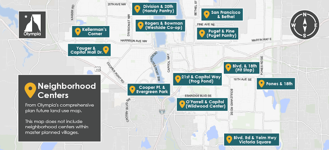
Olympia’s Comprehensive Plan identifies 17 locations for neighborhood centers. Conditions of these sites vary from thriving retail centers to vacant or completely undeveloped. Despite long-held goals to encourage them, neighborhood centers have not developed as envisioned. In 2014, the Olympia Planning Commission set out to find out why this was the case and to help create a path to implement the City’s vision. Early efforts included a community wide online survey and stakeholder interviews.
In January 2022, the City hired the consulting team of MAKERS Architecture & Urban Design and Leland Consulting Group gain a better understanding of barriers affecting neighborhood centers, and identify strategies for addressing these barriers. This team is focusing on the twelve neighborhood centers that are not part of Olympia’s master-planned communities.
View details about each of these 12 neighborhood centers at the bottom of this page.
The consultants spent the first half of 2022 evaluating each of the neighborhood centers, talking to stakeholders, and conducting a market analysis. The next phase of the project is to share findings from these efforts and get community input.
Community input
Your input is important for identifying actions the City can take to implement important community goals for walkable neighborhoods, reducing reliance on cars, and fostering neighborhood connections. Over 350 people participated in an online survey from July 13 - August 15.
-
Kaiser/Harrison (Kellerman’s Corner)
Share Kaiser/Harrison (Kellerman’s Corner) on Facebook Share Kaiser/Harrison (Kellerman’s Corner) on Twitter Share Kaiser/Harrison (Kellerman’s Corner) on Linkedin Email Kaiser/Harrison (Kellerman’s Corner) link
This center is located at the west end of Harrison Avenue. Commercial uses include a junk store and food truck. Woodbury Crossing, one of Olympia’s master-planned neighborhoods, is located to the west, and a bakery, produce stand and pub further to the east. This center was rezoned in 2016 from Neighbor Retail to High-Density Corridor 4 as part of the Kaiser-Harrison Opportunity Area Plan. Surrounding zoning includes Residential 4 – 8 dwelling units per acre and Residential 6 – 12 dwelling units per acre.
-
Yauger Way/Capital Mall Drive
Share Yauger Way/Capital Mall Drive on Facebook Share Yauger Way/Capital Mall Drive on Twitter Share Yauger Way/Capital Mall Drive on Linkedin Email Yauger Way/Capital Mall Drive link
Located in proximity to Capital Medical Center and other medical facilities, Yauger Park, and several apartment complexes. Capital Mall and other commercial areas are located to the east. Zoning in the areas includes Medical Services, Professional Office/Residential Multifamily, and Residential Multifamily 24 dwelling units per acre.
-
Division Street/20th Avenue (Handy Pantry)
Share Division Street/20th Avenue (Handy Pantry) on Facebook Share Division Street/20th Avenue (Handy Pantry) on Twitter Share Division Street/20th Avenue (Handy Pantry) on Linkedin Email Division Street/20th Avenue (Handy Pantry) link
Handy Pantry is located in the northeast corner of this intersection and is surrounded by low-density residential neighborhoods. Garden Raised Bounty (GruB) is located immediately to the east. It is predominantly auto-oriented due to lack of sidewalks in the area. The Handy Pantry site is zoned Neighborhood Retail; surrounding zoning includes Residential 4 – 8 dwelling units per acre and Residential Multifamily 18 dwelling units per acre.
-
Rogers Street/Bowman Avenue
Share Rogers Street/Bowman Avenue on Facebook Share Rogers Street/Bowman Avenue on Twitter Share Rogers Street/Bowman Avenue on Linkedin Email Rogers Street/Bowman Avenue link
The Westside Co-op and the Westside Grocery building are located in this neighborhood center. The Co-op, which also has a garden center, serves as a regional draw for shoppers. The Westside Grocery building was built in 1904 and served as a general store as West Olympia developed. Over the past several years, the first floor has been used for restaurants, with the upper floor for residential use. The Co-op and Westside Grocery building area zone Neighborhood Retail, surrounded by Residential 4 – 8 dwelling units per acre zoning.
-
Cooper Point Road/Evergreen Park Drive
Share Cooper Point Road/Evergreen Park Drive on Facebook Share Cooper Point Road/Evergreen Park Drive on Twitter Share Cooper Point Road/Evergreen Park Drive on Linkedin Email Cooper Point Road/Evergreen Park Drive link
This is a heavily developed areas with professional offices, apartments, condominiums, self-storage facility and gas stations. Percival Creek flows through this area. The Auto Mall is located to the northwest. Further beyond are extensive shopping areas along Black Lake Boulevard and Cooper Point Road. There is very little land area for establishing a neighborhood center, and this intersection is highly auto oriented. Zoning includes Evergreen Park Drive PUD, Auto Services, and General Commercial.
-
Capitol Way (Frog Pond)
Share Capitol Way (Frog Pond) on Facebook Share Capitol Way (Frog Pond) on Twitter Share Capitol Way (Frog Pond) on Linkedin Email Capitol Way (Frog Pond) link
Frog Pond is located in the South Capitol neighborhood at the intersection of Capitol Way and 21st Avenue. It is easily accessible by car, foot, or bike from surrounding neighborhoods and passing traffic. Frog Pond is zoned Neighborhood Retail. Adjacent zoning is predominantly Residential 6 – 12 dwelling units per acre with some Professional Office/Residential Multifamily west of Capitol Way.
-
O’Farrell Avenue/Capitol Way (Wildwood Center)
Share O’Farrell Avenue/Capitol Way (Wildwood Center) on Facebook Share O’Farrell Avenue/Capitol Way (Wildwood Center) on Twitter Share O’Farrell Avenue/Capitol Way (Wildwood Center) on Linkedin Email O’Farrell Avenue/Capitol Way (Wildwood Center) link
The Wildwood building was constructed in 1943 and is home to Vic’s, Lucky Lunchbox, Olympia Coffee Roasters, and Spuds. Like Frog Pond to the north, it is easily accessible by car, foot, or bike from surrounding neighborhoods and passing traffic. The Wildwood Center is zoned Neighborhood Retail, surrounded by Residential 4 – 8 dwelling units per acre zoning.
-
San Francisco Avenue/Bethel Street
Share San Francisco Avenue/Bethel Street on Facebook Share San Francisco Avenue/Bethel Street on Twitter Share San Francisco Avenue/Bethel Street on Linkedin Email San Francisco Avenue/Bethel Street link
The San Francisco Street Bakery has been a longtime business in northeast Olympia. It’s not just a storefront; it’s also the bakery’s distribution center for. A convenience store and vacant building are located across the street. Zoning in this area includes Neighborhood Retail, Residential 4 – 8 dwelling units per acre, and Residential 6-12 dwelling units per acre.
-
Pine Avenue/Puget Street (Puget Pantry)
Share Pine Avenue/Puget Street (Puget Pantry) on Facebook Share Pine Avenue/Puget Street (Puget Pantry) on Twitter Share Pine Avenue/Puget Street (Puget Pantry) on Linkedin Email Pine Avenue/Puget Street (Puget Pantry) link
Puget Pantry is corner convenience story in a single family neighborhood. There is a vacant lot across Pine Avenue with development potential. Puget Pantry is zoned Neighborhood Retail. Adjacent zoning is Residential 6 – 12 dwelling units per acre.
-
Boulevard Road/18th Avenue (Pit Stop)
Share Boulevard Road/18th Avenue (Pit Stop) on Facebook Share Boulevard Road/18th Avenue (Pit Stop) on Twitter Share Boulevard Road/18th Avenue (Pit Stop) on Linkedin Email Boulevard Road/18th Avenue (Pit Stop) link
The Pit Stop is a convenience store located at the northeast corner of Boulevard Road and 18th Ave. A church and small salon are also located in this center. With both streets being classified as major collectors and carrying a lot of traffic, this center is auto oriented. The Pit Stop is zoned Neighborhood Retail. Surrounding zoning include Residential 4 – 8 dwelling units per acre and Residential 6 -12 dwelling units per acre.
Documents
-
 Draft Olympia Neighborhood Centers Strategy (9.28 MB) (pdf)
-
Neighborhood Centers Survey Summary (1.79 MB) (pdf)
-
July 13 Open House Slides with Poll Results (14.2 MB) (pdf)
-
2022 Market Analysis (5.33 MB) (pdf)
-
Detailed Neighborhood Center Profiles (13.3 MB) (pdf)
-
2014 outreach summary (2.68 MB) (pdf)
-
Olympian article about Wildwood (175 KB) (pdf)
-
"Creating walkable business districts" by J Owen and G Easton (1.83 MB) (pdf)
